
The unified soil classification system (USCS) in geotechnical engineering
In this post we will discuss the topic of soil classification, focusing on two fundamental aspects: first, to understand what a soil classification system is; and second, to understand the philosophy of the Unified Soil Classification System, which is the most widely used around the world to differentiate soils in practical Geotechnical Engineering.
Contents
What is a soil classification system
In general, everyone has an idea that allows them to differentiate gravels, sands, silts and clays. However, from the point of view of Soil Mechanics, general terms such as gravel, sand, silt or clay include a wide range of engineering characteristics, so that further subdivisions or modifications of these terms are required to make them more useful in practical engineering. This results in the need for a systematic method to categorize and classify soil based on its most likely engineering behavior.

Figure 1 Appearance of different types of soils
Such classification method represents, therefore, a language of communication between engineers, so that it is not possible to confuse apparently similar soils, but which have different behaviors.
Another important advantage is that this language allows taking advantage of the experience accumulated by other engineers in similar soils, without the possibility of errors due to misinterpretation of the available information.
Figure 2 illustrates the role of the soil classification system in practical Geotechnical Engineering. As can be seen, from certain properties that a soil sample has (such as void ratio e, moisture content ω, density ρ, specific gravity Gs, liquid limit LL, and plastic index PI, among others), a classification system is applied, which allows the engineer to reach an approximate idea of the engineering properties of the soil and the behavior of the soil for different purposes.

Figure 2 Role of the soil classification system in Geotechnical Engineering
Of course, a soil classification system does NOT eliminate the need for detailed ground investigation, or more sophisticated testing to determine certain soil properties. However, the engineering properties correlate quite well with the index and classification properties of a given soil deposit. Thus, knowing the classification of the soil, the engineer will have a fairly good general idea about the potential of the soil to be used in a particular application and about its behavior during construction and under structural loads, over the life of the project (Holtz et al, 2011).
Evolution of the understanding of soil
The behavior of soils is very complex, mainly due to their granular nature and the coexistence of solid particles with interstitial fluid, which is generally composed of more than one fluid (water, salts, organic and inorganic contaminants, gases such as air and methane, etc.). The understanding of soil behavior has evolved through the 20th Century to the present day, from the understanding of the concept of effective stresses (Terzaghi, in the 1920s), the behavior of colloids and clays (Goy, Chapman in the '10s, Lambe and Mitchell in the '50s), shear expansion (Taylor, 1948), critical state soil mechanics (Roscoe, Schofield and Wroth in the 1960s), mixed fluid phase, and partially saturated soils (Bishop, Aitchinson, Fredlund and Morgenstern in the 1960s), to name some of the most important concepts (see Figure 3). In recent years, a new stage associated with the study of geochemistry mediated by micro-organisms has begun to develop (Santamarina and Narsilio, 2008).

Figure 3 Evolution over time of the understanding of soil behavior (Source: modified from Santamarina y Narsilio, 2008).
These advances in the understanding of soil behavior under different stresses or for different uses, allowed the development and improvement of different soil classification systems.
Philosophy of the Unified Soil Classification System
The Unified Soil Classification System (USCS) is governed by ASTM D-2487, and is the most widely used in geotechnical practice. It was initially proposed by Arthur Casagrande in 1932, tentatively adopted by the U.S. Department of Engineering in 1942, and finally submitted to the American Sociaty of Civil Engineers in 1948. The U.S. Army Corps of Engineers began using it in 1953, while the U.S. Bureau of Reclamation began using it in 1974. It is based on grain size analysis and Atterberg limits (liquid and plastic limits) of soils.
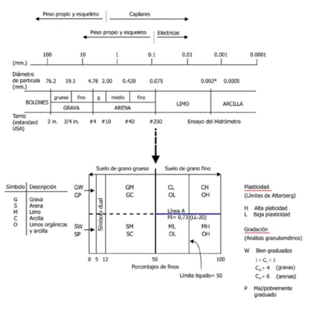
The system divides between coarse and fine soils, considering the percentage passing through the #200 sieve (0.075 mm). If less than 50% by weight of the soil passes through the #200 sieve, then the soil is coarse, and is sub-classified into sand or gravel by means of the #4 sieve. Otherwise, the soil is fine, and is sub-classified into silt or clay according to the values of the liquid and plastic limits. Figure 4 shows a simplified SUCS scheme.
The importance of the #200 sieve becomes evident when analyzing the forces acting between particles, including self-weight forces, forces due to effective stresses, electrical forces, and capillary forces. The correlation between the equivalent particle size and the nature of the governing forces can be seen in the upper part of Figure 4: the #200 and #4 sieves capture these limits. From a geotechnical design point of view, the rate of dissipation of excess pore pressure discriminates between analyses in "drained" and "undrained" conditions. Typically, "drained" loading conditions are associated with coarse-grained soils, while "undrained" loading conditions are associated with fine-grained soils.

Figure 4 Illustrative diagram of USCS (Source: modified from Santamarina y Narsilio, 2008).
In the absence of fines, the packing of coarse soil grains (gravel or sand) depends on the uniformity coefficient (Cu = D60/D10). On the other hand, the curvature coefficient (Cc = D302/(D10/D60) adds information about the convexity of the grain size curve, indicating the presence of extreme diameters (Santamarina and Narsilio, 2008).
It is important to note that even small amounts of fine particles (size less than 2 μm) can exert a great influence on the behavior of coarse soils. Fines fill the spaces between larger particles, control soil permeability, determine whether effective loading conditions will be drained or undrained, and change the stress-strain behavior of soils. In addition, a relatively small percentage of fine particles can form stable bridges between particles, conferring strength and stiffness to the soil (Santamarina et al, 2002). The SUCS recognizes these observations, and presents a variable range of fines between 5% and 12% that changes the classification of soils.
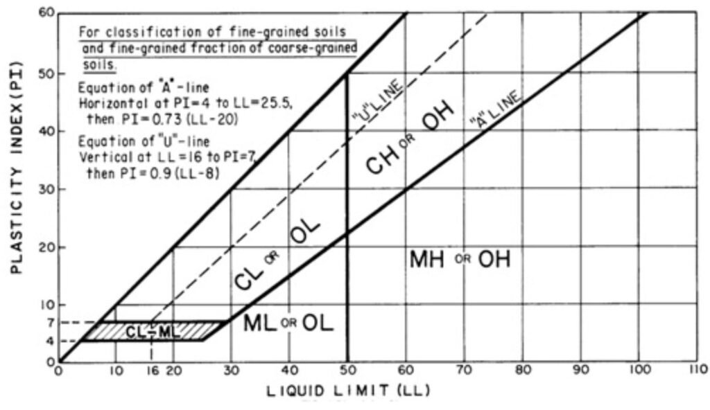
Atterberg limits, on the other hand, are used to classify fine soils. These tests quantify the specific surface area and factory formation. Consistency limit tests should be performed with the same fluid that will be involved during the life of the project, since the type and concentration of ions affect the effective thickness of the diffuse layer and the repulsive forces between particles (Santamarina and Narsilio, 2008). Figure 5 shows the Plasticity Chart, as presented in ASTM D-2487.

Figure 5 Plasticity Chart for USCS (Source: ASTM D-2487).
Finally, it is important to note that the USCS is based on routine laboratory tests: sieving and hydrometer particle size (the sieving test can be used), and consistency limits. This is perhaps the main practical strength of the system.
References
- “Annual Book of ASTM Standards: Soils and Rocks” (2019). American Society for Testing and Materials. USA.
- Holtz, R.; Kovacs, W. & Sheahan, T. (2011) “An Introduction to Geotechnical Engineering”. Second Edition. Prentice Hall. New Jersey, USA.
- Santamarina, C., Klein, K., Wang, Y., Prencke, E. (2002) “Specific Surface: Determination and Relevance”. DOI: 10.1139/T01-077. NRC. Canada.
- Santamarina, C., Narsilio, G. (2008) “Clasificación de Suelos: Fundamento Físico, Prácticas Actuales y Recomendaciones”. Conferencia 50 Aniversario Sociedad Venezolana de Geotecnia. Caracas, Venezuela.