
Hydrogeological assessment: a scientific approach to evaluating the feasibility of a deep well
The hydrogeological evaluation should be the starting point of any deep well project for groundwater development, since it provides fundamental information to decide the feasibility of the project at a given site, based on scientific, auditable and verifiable criteria and methodologies.
Content
Basic premises for hydrogeological assessment
In a deep well project for groundwater development, the main objective of the hydrogeological evaluation is to review some important aspects of the area where the deep well is planned or required, and to establish some minimum guidelines for its execution.
Basically, any hydrogeological evaluation seeks to answer three very important questions, which are shown in Figure 1.
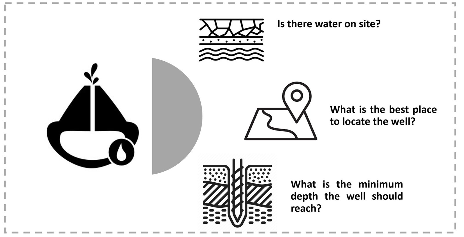
Figure 1 Basic premises in a hydrogeological assessment.
It is evident that these questions are the ones that any owner (whether a public or private entity) would ask himself before making an investment for the construction of a deep well. And it is precisely for this reason that the hydrogeological evaluation is so important as a starting point for the project, since it will allow estimating, by means of a scientific method, the probability of finding water in the subsoil of the studied area.
Preliminary analysis in a hydrogeological study
There is a mistaken belief that groundwater accumulates in subway lakes or flows in subway rivers. Nothing could be further from the truth. Groundwater is simply the subsurface water that completely saturates the pores or crevices of soils and rocks, as shown in Figure 2.
Es por eso que al iniciar una evaluación hidrogeológica, es importante analizar el paisaje del área de interés, dado que puede ofrecer pistas sobre la existencia de aguas subterráneas. Por ejemplo, debe tenerse presente que es más probable detectar aguas subterráneas poco profundas en mayores cantidades bajo los valles que bajo las colinas, dado que las aguas subterráneas obedecen a la ley de la gravedad, y por ende fluyen hacia abajo al igual que las aguas superficiales. En las regiones áridas, por su parte, la presencia de plantas “amantes del agua” es un indicio de la existencia de agua subterránea a poca profundidad o profundidad media. Asimismo, en cualquier zona en la que aparezca agua en la superficie (como manantiales, filtraciones, pantanos o lagos), debe existir agua subterránea, aunque no necesariamente en gran cantidad o de buena calidad.
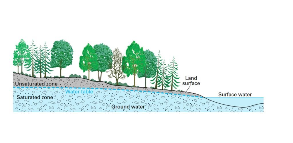
Figure 2 Groundwater: saturated and unsaturated zones (Source: modified from USGS, 2022. Available at https://www.usgs.gov/special-topics/water-science-school/science/how-do-hydrologists-locate-groundwater)
On the other hand, in case the site of interest is located in a rocky area, special attention should be paid to the formations that outcrop in the area: if the presence of sandstone, limestone or granite, which are porous rocks through which water can circulate, is detected, there is a higher probability of groundwater presence.
If, on the other hand, the area of interest is located in a valley, where unconsolidated sediments predominate, there will be a greater probability of detecting an exploitable aquifer in sand and gravel strata, which allow water to flow through the terrain.
According to the above, it is evident that the analysis of the landscape and climatic characteristics of the study area are very useful to develop a preliminary hydrogeological evaluation.
Step-by-step hydrogeological assessment
The U.S..G.S. (U.S. Geological Survey) recommends the following step-by-step approach for conducting a hydrogeologic assessment in a given area:
- Preparation of a geological map. In such a map, the different types of rock that outcrop on the surface of the ground must be included. The purpose of this map is to differentiate between those rocks that may be cracked and fissured, so that they provide openings to carry water to the subsoil, and those rocks that are either highly folded or relatively sound and little weathered.
- Gathering information on existing wells. It is important to have information on location, depth drilled, groundawter depth, amount of water pumped, level of drawdown, and types of rock penetrated by wells relatively close to the area of interest.
In case there are no wells in the area, or there is not enough information about the existing ones, it is necessary to construct some test wells, in order to determine the properties of the aquifer, especially how much water moves through the aquifer and the volumen of wáter that can enter the well.
- Water sampling. If the well will be built for human use, water quality is as important as quantity, so it will be necessary to take samples to perform physical-chemical tests on the water and evaluate its quality.
- Preparation of the hydrogeological evaluation. The report prepared by the hydrogeologist must include, as a minimum, the geological map indicating the best location to build the well and the minimum depth to be reached, as well as the estimate of the expected production and the physical-chemical characteristics of the water to be extracted.
As can be seen from the information summarized above, conducting a hydrogeological assessment provides the basis for making decisions on the feasibility of a deep well project, taking into account a scientific, auditable and verifiable approach.
References
- De Sola, O. (1967) “Hidrología y Propiedades de los Acuíferos”. Tema II de la obra Desarrollo de Aguas Subterráneas. Programa de Educación en Ingeniería Sanitaria de la Universidad Central de Venezuela. Caracas, Venezuela.
- Powers, P.; Corwin, A.; Schmall, P. & Kaeck, W. (2007) “Construction Dewatering and Groundwater Control”. Third Edition. John Wiley & Sons, Inc. New Jersey, USA.
- USGS (2022). How do hydrilogists locate groundwater? Disponible en https://www.usgs.gov/special-topics/water-science-school/science/how-do-hydrologists-locate-groundwater